
|
연간정보 서비스
상품코드
1765469
비GEO 위성 별자리 분석 툴킷 5.3Non-GEO Constellations Analysis Toolkit 5.3 |
||||||
'비GEO 위성 별자리 분석 툴킷(NCAT)'은 엄격한 데이터 기반 분석과 직관적인 사용자 경험을 결합하여 지구 저궤도(LEO) 및 중궤도(MEO) 위성 별자리에 대한 객관적인 평가를 제공합니다.

NCAT는 다양한 데이터 세트, 고급 분석, 인터랙티브 시각화, AI 기능을 통합하여 전략가, 비즈니스 리더, 기술 전문가에게 비 정지궤도(비지상위성) 위성 별자리(Non-GEO) 능력과 영향에 대한 신뢰할 수 있는 통찰력을 제공합니다.
사용자 친화적인 온라인 웹 앱으로 제공되며, 대역폭 수급 동향을 직관적으로 파악하고, 시장의 해결 가능성을 평가하고, 비즈니스 사례의 민감도를 검증할 수 있습니다. 또한, 위성 관련 데이터 및 발사 통계에 대한 상세한 분석도 가능합니다.
NCAT는 주요 성능 지표를 자동으로 산출하고, 위성 컨스텔레이션 간은 물론 지상 네트워크와 비교하여 그 경쟁력을 벤치마킹합니다. 이 모든 것을 전문적인 기술 지식 없이도 원활하게 수행할 수 있는 것이 특징입니다.
대상 범위
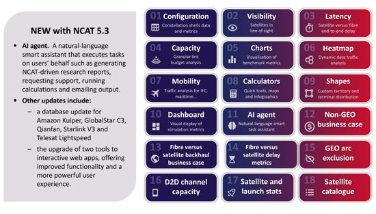
수만 줄의 원본 코드와 수백만 개의 쿼리 가능한 데이터베이스 레코드로 구동되는 18개의 통합 툴은 여러 수준에서 위성 별자리 성능에 대한 객관적인 데이터 기반 평가를 제공합니다. 수백만 개의 동적 계산은 구성 가능한 필터, 시각화 컨트롤, 사용자 정의 입력이 가능한 직관적인 인터페이스를 통해 처리됩니다. 모든 출력 데이터(데이터 표, 차트, 시각화)는 추가 분석 및 보고서 작성에 활용할 수 있도록 쉽게 다운로드할 수 있습니다.
특징
- 엄격하게 코딩된 알고리즘을 통해 사실에 기반한 분석과 시각화를 수행합니다.
- 종합적이고 정기적으로 업데이트되는 데이터베이스. 최신 시뮬레이션을 실행할 수 있습니다.
- 일일 업데이트: 궤도상의 위성 수 및 궤도 관측
- 주간 업데이트(일요일) : 위성 카탈로그
- 월간 업데이트: 위성 및 발사 통계
- 분기별 업데이트: 핵심 소프트웨어 및 데이터베이스 기능 강화
- 포인트 앤 클릭의 양방향성: 인터랙티브 맵과 컨트롤(레이어, 필터, 버튼, 설정 등)을 쉽게 조작할 수 있으며, 몇 번의 클릭만으로 확대 및 축소, 사용자 단말기의 위치 설정, 동적 계산 및 시각화를 할 수 있습니다.
- 다중 궤도, 다중 대역 분석 : 시뮬레이션은 하나 또는 여러 시스템의 궤도 쉘 조합에 걸쳐 설정할 수 있으므로, 서로 다른 주파수 대역에 걸쳐 수천 개의 위성을 동시에 계산할 수 있습니다.
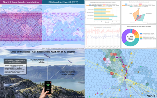
- 동적 애니메이션 표시: 위성 위치, 커버리지 실적, 가시 위성, 안테나 룩앵글, 링크 지연 변동, 수급 히트맵 등 주요 조건의 실시간 전파를 표시할 수 있습니다.
- 시공간 제어: NCAT5는 세계, 지역, 로컬 스케일의 실시간 분석과 가속 타임랩스 분석을 모두 지원합니다. 시뮬레이션은 최대 300배까지 가속화할 수 있으며, 약 5분 만에 하루의 별자리 성능을 분석할 수 있습니다.
- 육각형 지상 그리드: NCAT5는 국가 수준의 정밀도를 가진 동적 육각형 그리드를 채택하여 도시 규모의 해상도(셀 반경 9km)까지 설정 가능하며, 'Shapes' 툴을 사용하면 NCAT 데이터베이스에 미리 등록된 250개 이상의 국가 및 지역 외에도 커스텀 지역을 정의할 수 있습니다.
- IP 처리량 동시 계산: NCAT5는 사용자 단말과 게이트웨이의 룩앵글 조합을 고려하면서 모든 사용자 빔과 게이트웨이 빔에서 링크 예산의 처리량 분석을 동시에 수행합니다.
- 유연한 수요 모델: 미리 설정된 수요 기준에서 선택하거나 사용자 정의 수요 매개변수(사용자 단말기 분포 및 대역폭 수요의 기능적 드라이버 포함)를 정의하여 특정 이용 사례에 맞는 시뮬레이션을 수행할 수 있습니다.
- 수요 주도형 공급: NCAT는 선택 가능한 공정 기준에 따라 스티어러블 빔 용량의 동적 재구성을 시뮬레이션하여 변화하는 수요 조건에 따라 실현 가능한 공급을 최적으로 일치시킵니다.
- 모빌리티 도구: NCAT는 사용자 정의 스케줄을 통해 다양한 모빌리티 용도(기내 Wi-Fi, 철도, 해상, 커넥티드카 등)을 지원합니다. 또한, NCAT는 수만 개의 노선, 항공사, 공항을 포괄하는 실시간 상용 비행 데이터를 통합하여 기내 연결(IFC) 수요 및 공급의 역동성을 평가합니다.
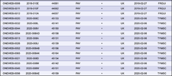
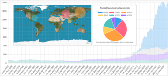
- 통계: NCAT5는 종합적인 카탈로그 데이터와 위성 발사 통계에 접근하고 처리하며, 1957년 이후 우주로 발사된 61,000개 이상의 미분류된 물체의 데이터를 검색할 수 있는 설정 가능한 필터를 사용자에게 제공합니다.
- 보고서 작성: AI 에이전트 도구는 자연어를 사용하여 NCAT 내부의 도구 및 데이터 세트와 원활하게 상호 작용하고, 쿼리에 대한 답변, 전문 보고서 작성, 시뮬레이션 결과 해석을 가능하게 합니다.
- 다운로드 가능한 차트 및 데이터: 모든 차트, 지도, 인포그래픽은 PDF 또는 PNG 형식으로 다운로드할 수 있습니다. 출력 데이터는 표 형식의 CSV 형식으로 제공되어 플랫폼 외부에서 추가 분석이 가능합니다. 다운로드 가능한 컨텐츠에는 표, 차트 데이터, 지도, 벤치마크 지표, 타임스탬프가 찍힌 샘플, 수급 데이터가 포함된 지상 그리드, 평가 요약, 비행 경로, 시야각 통계, 빔 이용률 등이 포함됩니다.
애플리케이션 |
NCAT는 위성통신(satcom)에 초점을 맞추고 있지만, 지구관측(EO)과 전지구항법위성시스템(GNSS)을 평가하는 기능도 포함되어 있습니다. |
도구 |
18개의 설정 가능한 도구를 통해 다음과 같은 다각적인 분석 및 벤치마킹이 가능합니다.
|
컨스텔레이션 쉘: |
100개 이상의 운영 중, 계획 중, 제출된 시스템을 수록(사용자 편집 및 확장 가능) |
게이트웨이: |
370개 이상의 조사된 게이트웨이 위치(사용자가 편집 및 확장 가능) |
지리적 지역: |
250개 이상의 국가, 지역, 지역, 지역, 하위 지역이 포함됩니다(사용자 편집 및 확장 가능). |
자주 묻는 질문에 대한 답변
- 현재 및 미래 NGSO 아키텍처의 커버리지, 용량, 빔, 위성 벤치마크는?
- 게이트웨이, 사용자 빔, 위성별, 포워드 링크 및 리턴 링크의 용량(스펙트럼, 대역폭, IP 처리량)은 얼마인가?
- 국가별, 지역별로 동시에 몇 명의 사용자를 지원할 수 있는가?
- 사용 가능한 초당 메가비트 당 자본 비용은 어떻게 결정될 수 있는가?
- 우주선 제작 및 발사 비용에 대한 비즈니스 사례의 민감도는?
- 위성통신 컨스텔레이션은 서비스가 충분히 제공되지 않는 지역에서 어떤 경우에 광섬유보다 우수한 성능을 발휘할 수 있을까?
- 백홀의 설비투자와 고정비용이 비즈니스 사례에 어떤 영향을 미칠까?
- 설정 가능한 서비스 계획에 따라 대역폭 수요 및 공급을 어떻게 평가할 수 있으며, 혼잡한 핫스팟은 어디인가?
- 위도와 궤도 쉘의 차이에 따른 위성의 최대, 평균, 최소 개수는?
- POP, 광위성 간 링크(OISL), 링크 릴레이를 고려했을 때, 광섬유의 지연은 LEO 시스템의 지연과 어떻게 비교되는가?
- GEO 간섭을 피하기 위한 비 GEO 시스템의 규제 제외 각도는?
본 툴박스 대상 사용자:
- 위성사업자(GEO, 비GEO, FSS, MSS/D2D)
- 위성 제조업체 및 부품 공급업체
- 지상/무선 네트워크 사업자(통신사업자, MNO, ISP, 타워코스, 클라우드 서비스 제공업체 등)
- 지상 시스템 벤더(단말, 안테나, 허브/모뎀, SD-WAN)
- 텔레포트 운영자,위성 서비스 제공업체,GEO-비GEO 통합업체
- 주요 비GEO 용량 사용자(정부, 국방부, 항공사, 에너지 회사 등)
- 산업체, 연구실 및 연구기관
- 가상 별자리 소프트웨어를 개발하는 IT 기업
- 규제 당국 및 주파수 조사 기관
- 금융기관 및 투자회사
포함되는 위성 시스템(예시)
|
|
NCAT은 온라인에서 설정 가능한 툴셋으로 무제한 이용이 가능합니다. 또한, 인허가, 운영, 계획 중인 주요 비GEO 위성시스템의 데이터셋이 미리 탑재되어 제공됩니다.
LSH 25.07.16
The 'Non-GEO Constellations Analysis Toolkit (NCAT)' combines rigorous, data-driven analysis with an intuitive user experience to deliver objective assessments of low-Earth orbit (LEO) and medium-Earth orbit (MEO) satellite constellations.
NCAT equips strategists, business leaders and technical professionals with reliable insights into the capabilities and impact of non-geostationary (non-GEO) constellations by integrating diverse datasets, advanced analytics, interactive visualisations and AI capabilities.
NCAT is delivered as a user-friendly online web app, and empowers users to seamlessly explore bandwidth supply and demand dynamics, assess market addressability, evaluate business case sensitivities and delve into satellite data and launch statistics. The platform automatically calculates key performance metrics and benchmarks the competitiveness of satellite constellations (both against each other and relative to terrestrial networks), all without requiring deep technical expertise.
Toolkit coverage
18 integrated tools, driven by tens of thousands of lines of original code and millions of queryable database records, provide objective, data-driven assessments of constellation performance at multiple levels. Millions of dynamic calculations are processed via an intuitive interface with configurable filters, visualisation controls and user-defined inputs. All outputs (data tables, charts and visualisations) are easily downloadable for further analysis or reporting.

Features included:
- Rigorously coded algorithms that drive factual analytics and visualisations.
- A comprehensive, regularly updated database. This enables users to run up-to-date simulations.
- Daily: in-orbit satellite counts and orbital observations are updated automatically every day.
- Weekly: the satellite catalogue is updated automatically each Sunday.
- Monthly: satellite and launch statistics are refreshed automatically every month.
- quarterly: core software and database enhancements are deployed every quarter.
- Point-and-click interactivity. Users can easily navigate interactive maps and controls (such as layers, filters, buttons and settings) to zoom in and out, set user terminal locations and drive dynamic calculations and visualisations with just a few clicks.
- Multi-orbit, multi-band analysis. Simulations can be configured across combinations of orbital shells from one or multiple systems, thus enabling concurrent calculations for thousands of satellites across different frequency bands.
- Dynamic, animated visualisations. Users can view real-time propagation of key conditions, including satellite positions, coverage footprints, visible satellites, antenna look angles, link latency variations and supply-demand heatmaps.
- Space-time controls. NCAT5 supports both real-time and accelerated time-lapse analysis at global, regional or local scales. Simulations can be sped up by up to 300x, enabling users to analyse a full day of constellation performance in around 5 minutes.
- Hexagonal ground grid. NCAT5 employs a dynamic hexagonal grid with country-level precision, configurable down to city-scale resolution (~9 km cell radius). The 'Shapes' tool enables users to define custom geographical areas beyond the 250+ countries and regions preloaded in the NCAT database.
- Concurrent IP throughput computations. NCAT5 performs concurrent link-budget throughput analysis across all user and gateway beams, accounting for combinations of user-terminal and gateway look angles.
- Flexible demand models. The toolset enables users to choose from pre-set demand criteria or define custom demand parameters (including user terminal distribution and functional drivers of bandwidth demand) to tailor simulations to specific use cases.
- Demand-driven supply. NCAT simulates dynamic reconfigurations of steerable beam capacity based on selectable fairness criteria to optimally match feasible supply with changing demand conditions.
- Mobility tool. NCAT supports a wide range of mobility applications (such as in-flight Wi-Fi, rail, maritime and connected vehicles) through user-defined schedules. Additionally, NCAT integrates real-time commercial flight data, covering tens of thousands of routes, airlines and airports, to assess in-flight connectivity (IFC) supply and demand dynamics.
- Statistics. NCAT5 accesses and processes comprehensive catalogued data and satellite launch statistics, presenting users with configurable filters to explore data for over 61 000 unclassified objects launched into space since 1957.
- Report generation. The AI Agent tool uses natural language to interact seamlessly with internal NCAT tools and datasets, enabling it to answer queries, generate professional reports and interpret simulation results.
- Downloadable charts and data. All charts, maps and infographics can be downloaded in PDF or PNG format. Output data is available in tabular CSV format, enabling further analysis outside the platform. Downloadable content includes tables, chart data, maps, benchmark metrics, time-stamped samples, terrestrial grids with supply and demand data, assessment summaries, flight routes, look angle statistics, beam utilisation and more.
Applications:
NCAT is focused on satellite communications (satcom) but includes features to assess Earth observation (EO) and global navigation satellite systems (GNSS).
Tools:
18 configurable tools to analyse and benchmark systems from multiple angles, including:
- satellite visibility and revisit rates
- IP throughput, beam and satellite capacity
- bandwidth supply and demand
- direct-to-device (D2D) channel capacity
- business case sensitivity
- end-to-end latency
- launch and satellite statistics.
Constellation shells:
100+ operational, planned and filed systems included (user editable and expandable).
Gateways:
370+ surveyed gateway locations (user editable and expandable).
Geographical regions:
250+ countries, territories, regions and subregions included (user editable and expandable).

Questions answered:
- How do current and future NGSO architectures benchmark across coverage, capacity, beam, and satellites?
- What is the forward and return link capacity (spectrum, bandwidth and IP throughput) per gateway, user beam and satellite?
- How many users can constellations support simultaneously, by country or territory?
- How can the capital cost per usable megabits per second be determined?
- What is the business-case sensitivity to spacecraft manufacturing and launch costs?
- When can satcom constellations outperform fibre-optics in underserved communities?
- How does backhaul capex and opex affect the business case?
- How can bandwidth supply and demand be assessed, based on configurable service plans, and where are the congestion hotspots?
- What is the maximum, average and minimum number of satellites in view or line of sight at different latitudes and orbital shells?
- How does fibre latency compare with that of LEO systems, factoring in POPs, optical inter-satellite links (OISLs) and link relays?
- What are the regulatory exclusion angles for non-GEO systems to avoid GEO interference?


Who should use this toolbox:
- Satellite operators (GEO, non-GEO, FSS and MSS/D2D)
- Spacecraft manufacturers and component vendors
- Terrestrial/wireless network operators (telecoms operators, MNOs, ISPs, towercos, cloud services providers and so on)
- Ground system vendors (terminals, antennas, hub/modems and SD-WAN)
- Teleport operators, satellite service providers and GEO-non-GEO integrators
- Major non-GEO capacity users (such as governments, defence players, airlines and energy companies)
- Industry associations, research labs and institutions
- IT companies developing virtualised constellation software
- Regulators and spectrum research agencies
- Financial institutions and investment firms
Satellite systems included (examples):
- Amazon Project Kuiper
- AST SpaceMobile
- Boeing
- E-Space
- G60 Thousand Sails (Qianfan)
- Globalstar
- Hughes
- Inmarsat Orchestra
- Intelsat MEO
- Iridium
- Kepler
- Lynk Global
- Mangata Networks
- Omnispace
- OneWeb
- Rivada
- SES mPOWER & O3b
- SpaceX Starlink
- Telesat Lighspeed
- ViaSat
As an online configurable toolset, NCAT has unlimited usability and is delivered pre-populated with datasets for leading non-GEO systems, including granted, operating and proposed systems.
The 'Non-GEO Constellations Analysis Toolkit (NCAT)' combines rigorous, data-driven analysis with an intuitive user experience to deliver objective assessments of low-Earth orbit (LEO) and medium-Earth orbit (MEO) satellite constellations.
NCAT equips strategists, business leaders and technical professionals with reliable insights into the capabilities and impact of non-geostationary (non-GEO) constellations by integrating diverse datasets, advanced analytics, interactive visualisations and AI capabilities.
NCAT is delivered as a user-friendly online web app, and empowers users to seamlessly explore bandwidth supply and demand dynamics, assess market addressability, evaluate business case sensitivities and delve into satellite data and launch statistics. The platform automatically calculates key performance metrics and benchmarks the competitiveness of satellite constellations (both against each other and relative to terrestrial networks), all without requiring deep technical expertise.
Toolkit coverage
18 integrated tools, driven by tens of thousands of lines of original code and millions of queryable database records, provide objective, data-driven assessments of constellation performance at multiple levels. Millions of dynamic calculations are processed via an intuitive interface with configurable filters, visualisation controls and user-defined inputs. All outputs (data tables, charts and visualisations) are easily downloadable for further analysis or reporting.
Features included:
- Rigorously coded algorithms that drive factual analytics and visualisations.
- A comprehensive, regularly updated database. This enables users to run up-to-date simulations.
- Daily: in-orbit satellite counts and orbital observations are updated automatically every day.
- Weekly: the satellite catalogue is updated automatically each Sunday.
- Monthly: satellite and launch statistics are refreshed automatically every month.
- quarterly: core software and database enhancements are deployed every quarter.
- Point-and-click interactivity. Users can easily navigate interactive maps and controls (such as layers, filters, buttons and settings) to zoom in and out, set user terminal locations and drive dynamic calculations and visualisations with just a few clicks.
- Multi-orbit, multi-band analysis. Simulations can be configured across combinations of orbital shells from one or multiple systems, thus enabling concurrent calculations for thousands of satellites across different frequency bands.
- Dynamic, animated visualisations. Users can view real-time propagation of key conditions, including satellite positions, coverage footprints, visible satellites, antenna look angles, link latency variations and supply-demand heatmaps.
- Space-time controls. NCAT5 supports both real-time and accelerated time-lapse analysis at global, regional or local scales. Simulations can be sped up by up to 300x, enabling users to analyse a full day of constellation performance in around 5 minutes.
- Hexagonal ground grid. NCAT5 employs a dynamic hexagonal grid with country-level precision, configurable down to city-scale resolution (~9 km cell radius). The 'Shapes' tool enables users to define custom geographical areas beyond the 250+ countries and regions preloaded in the NCAT database.
- Concurrent IP throughput computations. NCAT5 performs concurrent link-budget throughput analysis across all user and gateway beams, accounting for combinations of user-terminal and gateway look angles.
- Flexible demand models. The toolset enables users to choose from pre-set demand criteria or define custom demand parameters (including user terminal distribution and functional drivers of bandwidth demand) to tailor simulations to specific use cases.
- Demand-driven supply. NCAT simulates dynamic reconfigurations of steerable beam capacity based on selectable fairness criteria to optimally match feasible supply with changing demand conditions.
- Mobility tool. NCAT supports a wide range of mobility applications (such as in-flight Wi-Fi, rail, maritime and connected vehicles) through user-defined schedules. Additionally, NCAT integrates real-time commercial flight data, covering tens of thousands of routes, airlines and airports, to assess in-flight connectivity (IFC) supply and demand dynamics.
- Statistics. NCAT5 accesses and processes comprehensive catalogued data and satellite launch statistics, presenting users with configurable filters to explore data for over 61 000 unclassified objects launched into space since 1957.
- Report generation. The AI Agent tool uses natural language to interact seamlessly with internal NCAT tools and datasets, enabling it to answer queries, generate professional reports and interpret simulation results.
- Downloadable charts and data. All charts, maps and infographics can be downloaded in PDF or PNG format. Output data is available in tabular CSV format, enabling further analysis outside the platform. Downloadable content includes tables, chart data, maps, benchmark metrics, time-stamped samples, terrestrial grids with supply and demand data, assessment summaries, flight routes, look angle statistics, beam utilisation and more.
Applications: |
NCAT is focused on satellite communications (satcom) but includes features to assess Earth observation (EO) and global navigation satellite systems (GNSS). |
Tools: |
18 configurable tools to analyse and benchmark systems from multiple angles, including:
|
Constellation shells: |
100+ operational, planned and filed systems included (user editable and expandable). |
Gateways: |
370+ surveyed gateway locations (user editable and expandable). |
Geographical regions: |
250+ countries, territories, regions and subregions included (user editable and expandable). |
Questions answered:
- How do current and future NGSO architectures benchmark across coverage, capacity, beam, and satellites?
- What is the forward and return link capacity (spectrum, bandwidth and IP throughput) per gateway, user beam and satellite?
- How many users can constellations support simultaneously, by country or territory?
- How can the capital cost per usable megabits per second be determined?
- What is the business-case sensitivity to spacecraft manufacturing and launch costs?
- When can satcom constellations outperform fibre-optics in underserved communities?
- How does backhaul capex and opex affect the business case?
- How can bandwidth supply and demand be assessed, based on configurable service plans, and where are the congestion hotspots?
- What is the maximum, average and minimum number of satellites in view or line of sight at different latitudes and orbital shells?
- How does fibre latency compare with that of LEO systems, factoring in POPs, optical inter-satellite links (OISLs) and link relays?
- What are the regulatory exclusion angles for non-GEO systems to avoid GEO interference?
Who should use this toolbox:
- Satellite operators (GEO, non-GEO, FSS and MSS/D2D)
- Spacecraft manufacturers and component vendors
- Terrestrial/wireless network operators (telecoms operators, MNOs, ISPs, towercos, cloud services providers and so on)
- Ground system vendors (terminals, antennas, hub/modems and SD-WAN)
- Teleport operators, satellite service providers and GEO-non-GEO integrators
- Major non-GEO capacity users (such as governments, defence players, airlines and energy companies)
- Industry associations, research labs and institutions
- IT companies developing virtualised constellation software
- Regulators and spectrum research agencies
- Financial institutions and investment firms
Satellite systems included (examples):
|
|
As an online configurable toolset, NCAT has unlimited usability and is delivered pre-populated with datasets for leading non-GEO systems, including granted, operating and proposed systems.