

|
시장보고서
상품코드
2154996
남미의 라이더 : 시장 점유율 분석, 업계 동향과 통계, 성장 예측(2026-2031년)South America Lidar - Market Share Analysis, Industry Trends & Statistics, Growth Forecasts (2026 - 2031) |
||||||
 Mordor Intelligence
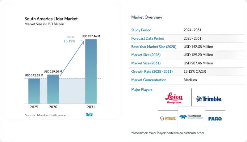
에 따르면 남미의 리다르 시장 규모는 2025년 1억 4,235만 달러에서 2026년에는 1억 5,914만 달러로 확대하며, 2031년까지 3억 2,173만 달러에 달할 것으로 예상되고 있으며, 2026-2031년에 CAGR 15.12%로 성장할 것으로 전망되고 있습니다.
남미 LiDAR 시장의 동향 및 인사이트
UAV 및 드론을 활용한 측량 업무의 확대
장거리 비행이 가능한 드론에 탑재된 경량 LiDAR 페이로드를 통해 1헥타르당 측량 비용이 절감되고, 외진 지역 접근성이 개선되고 있습니다. 브라질 고이아스 주의 구리·금 광산에서는 Zenmuse L3 LiDAR 시스템을 탑재한 DJI Matrice 400이 3cm의 정밀도를 달성했습니다. 이 프로젝트에서는 지상 기반 GNSS RTK 방식에 비해 실행 시간을 50% 단축하여, 가동중인 채굴 작업을 방해하지 않고 진행할 수 있었습니다. 브라질의 4개 주에 걸쳐 있는 184km 철도 측량 프로젝트에서는 지상에서 접근하기 어려운 지역에서도 항공 LiDAR가 회랑 측량을 지원할 수 있음이 입증되었습니다. 신속한 전개가 가능해짐에 따라 지역 사업자들은 이전에는 대응하기 어려웠던 소규모 프로젝트에도 참여할 수 있게 되었습니다.
광업 및 임업 분야의 고정밀 지형 데이터 수요
광업, 임업 및 관련 규정 준수 활동은 남미의 LiDAR 시장에서 지속적인 수요를 창출하고 있습니다. 이러한 활동에서는 안전 평가, 부피 측정, 환경 문서 작성을 위해 지형 데이터가 필요합니다. 2025년에는 칠레에서 광상 및 광미의 3D 모니터링을 위해 모바일 LiDAR 스캔이 도입될 전망입니다. 많은 광업 및 임업 현장에서는 수관이 빽빽하게 자라 있으며, 기존의 사진 측량만으로는 충분한 효과를 얻을 수 없습니다. LiDAR는 식생 아래에 있는 지형의 특성을 식별할 수 있으므로 보다 포괄적인 현장 평가가 가능해집니다. 그 결과, 조달 계획은 규정 준수 일정 및 상품 투자 주기와 밀접하게 연계되어 있습니다.
높은 도입 비용과 후처리 비용
측량 등급의 항공 측량 시스템에는 레이저 스캐너, GNSS, IMU 및 처리 소프트웨어가 통합되어 있습니다. 수입 장비의 가격은 일반적으로 10만 달러에서 30만 달러 사이입니다. 많은 지역 서비스 기업이나 공공기관에게 있으며, 이토록 막대한 설비 투자를 쉽게 감당하기는 어렵습니다. 또한 후처리에는 라이선스가 부여된 소프트웨어, 훈련을 받은 인력, 그리고 엄격한 품질관리 절차가 필요합니다. 수관이 빽빽한 경우, 분류나 지형 모델 생성은 더욱 복잡해집니다. 데이터-어즈-어-서비스(DaaS) 계약을 통해 초기 장비 비용은 절감되지만, 그 결과 제한된 수의 사업자에게 처리 능력이 집중될 가능성이 있습니다.
부문 분석
항공 LiDAR는 2025년에 매출의 34.00%를 차지할 것으로 예측되며, 남미 LiDAR 시장에서 주도적인 위치를 유지할 것으로 전망됩니다. 항공기를 통한 데이터 수집은 열대 우림의 수관이나 안데스 산맥의 지형을 횡단하는 대규모 측량에 최적이며, 도로 접근이나 지상 측량이 어려운 지역에서도 광범위한 영역을 커버할 수 있습니다. 2026년 4월, Hexagon R-evolution은 Vale사의 아구아스 클라라스 광산에서 복구 임무를 수행할 예정입니다. 이 프로젝트에서는 광산 자산 관리를 지원하기 위해 라이카 지오시스템즈의 하이브리드 항공 측량 시스템을 사용하여, 1제곱미터당 40포인트가 넘는 밀도로 20제곱킬로미터 이상의 지역을 매핑할 예정입니다. 지상형, 이동형 및 고정형 지상 시스템은 폐쇄적인 산업 시설, 도시 지역 및 지하 광산에 대응합니다. 이러한 고정 스캔 방식은 상세한 구조물 기록을 가능하게 합니다.
수심 측량용 LiDAR 시장은 2031년까지 연평균 성장률(CAGR) 18.50%로 확대될 것으로 예상되며, 이는 남미 LiDAR 시장내 제품 유형 중 가장 높은 성장률입니다. 이 성장 부문을 지원하는 것은 해상 및 연안 지역의 측량 수요입니다. 브라질의 대서양 연안은 단기적으로 해상 에너지 활동의 주요 거점이 될 것으로 전망됩니다. 2026년 4월, 후구로(Fugro)사는 브라질의 18MW 리우데자네이루 해상 풍력 시범 프로젝트에 대한 지질 조사를 위해 페트로브라스(Petrobras)사로부터 계약을 수주할 전망입니다. 이 프로젝트는 브라질 환경·재생 가능 천연자원청(IBAMA)의 공식 라이선싱 절차를 밟게 될 남미 최초의 해상 풍력 개발 프로젝트가 될 전망입니다. 조사 작업은 2026년 4월부터 3분기까지 진행될 예정입니다. 이 계약은 연안 개발이 수심 측량 데이터 및 연안 지역 데이터에 대한 지속적인 수요를 창출할 것임을 보여줍니다.
레이저 스캐너는 2025년에 부품 매출의 40.00%를 차지할 것으로 예측되며, 남미 LiDAR 시장에서 부품별 최대 점유율을 차지할 전망입니다. 에미터·검출기 어셈블리는 LiDAR 구성에서 가장 고가의 하위 시스템인 경우가 많으며, 점 밀도, 거리 측정 범위, 정확도 등의 주요 성능 지표를 결정합니다. 라이카 지오시스템즈는 2026년 6월에 지상형 스캐너 ‘RTC300’, ‘RTC500’, ‘RTC700’을 출시할 예정입니다. 이 시리즈에는 Hexagon GeoCloud로의 Livelink 스트리밍 기능이 탑재되어 있으며, 인프라 및 디지털 트윈 워크플로우를 위한 지상형 스캔에 대한 지속적인 투자가 반영되어 있습니다. GNSS 및 카메라는 통합 시스템에서 계속해서 중요한 보조 구성 요소가 될 것입니다.
IMU 시장은 2031년까지 연평균 성장률(CAGR) 16.20%로 확대될 것으로 예측되며, 가장 빠르게 성장하는 구성 요소 그룹이 될 전망입니다. 드론 플랫폼에서는 비행 중 롤, 피치, 요의 정확한 보정이 필요하며, 센티미터 수준의 포인트 클라우드 품질을 유지하기 위해서는 정확한 궤적 데이터가 필수적입니다. 이러한 요구 사항은 수관 투과 및 회랑 매핑 임무에서 점점 더 중요해지고 있습니다. YellowScan사는 Trimble Applanix APX-RTX IMU를 탑재한 ‘Venturer’를 2026년 2월에 출시할 예정입니다. 이 시스템은 UAV용 LiDAR 선정시 자세 측정 정확도를 중요한 고려 사항으로 삼고 있습니다. 강화된 모션 보정 기능을 통해 운영자는 변화하는 비행 조건에서도 일관된 데이터 품질을 유지할 수 있습니다.
기타 혜택:
- 엑셀 형식의 시장 예측(ME) 시트
- 3개월간의 애널리스트 지원
자주 묻는 질문
목차
제1장 서론
- 조사 전제조건과 시장 정의
- 조사 범위
제2장 조사 방법
제3장 개요
제4장 시장 구도
- 시장 개요
- 거시경제 요인이 시장에 미치는 영향
- 시장 성장 촉진요인
- 시장 성장 억제요인
- 업계 밸류체인 분석
- 규제 상황
- 기술 전망
- Porter's Five Forces 분석
제5장 시장 규모와 성장 예측, 금액 및 수량
- 제품 유형별
- 컴포넌트별
- 기술별
- 범위별
- 설치 형태별
- 용도별
- 지역별
- 브라질
- 아르헨티나
- 칠레
- 기타 남미 국가
제6장 경쟁 구도
- 시장 집중도
- 전략적 동향
- 시장 점유율 분석
- 기업 개요
- Leica Geosystems AG
- Trimble Inc.
- Teledyne Technologies Incorporated
- FARO Technologies, Inc.
- RIEGL Laser Measurement Systems GmbH
- SICK AG
- Hexagon AB
- YellowScan
- Topcon Corporation
- TerraSolid Ltd.
- Ouster, Inc.
- Innoviz Technologies Ltd.
- Hesai Group
- RoboSense Technology Co., Ltd.
- LeddarTech Inc.
- DENSO Corporation
- XMobots Aeroespacial e Sistemas S.A.
- Santos Lab Comercio e Industria Aeroespacial Ltda.
- Quantum Spatial, Inc.
- Fugro N.V.
제7장 시장 기회와 향후 전망
KSA 26.10.28According to Mordor Intelligence, the South America lidar market size is expected to increase from USD 142.35 million in 2025 to USD 159.14 million in 2026 and reach USD 321.73 million by 2031, growing at a CAGR of 15.12% over 2026-2031.
South America Lidar Market Trends and Insights
Expansion of UAV and Drone-Based Surveying
Lightweight LiDAR payloads deployed on longer-endurance drones reduce survey costs per hectare and improve access to remote sites. At a copper-gold mine in Goias, Brazil, a DJI Matrice 400 equipped with a Zenmuse L3 LiDAR system achieved 3 cm accuracy. The project reduced execution time by 50% compared with ground-based GNSS RTK methods and proceeded without disrupting active mining operations. A 184 km railway mapping project across four Brazilian states demonstrated that aerial LiDAR can support corridor surveys in areas that are difficult to access from the ground. Faster mobilization enables regional operators to compete for smaller assignments that were previously more challenging to serve.
Mining and Forestry Demand for High-Precision Terrain Data
Mining, forestry, and related compliance activities generate recurring demand in the South American LiDAR market. These activities require terrain data for safety assessments, volume measurements, and environmental documentation. In 2025. Chile is expected to adopt mobile LiDAR scanning for 3D monitoring of mine deposits and tailings. Dense canopy cover reduces the effectiveness of conventional photogrammetry across many mining and forestry sites. LiDAR can identify terrain features beneath vegetation, enabling more comprehensive site assessments. Consequently, procurement is tied to compliance schedules and commodity investment cycles.
High Acquisition and Post-Processing Costs
Survey-grade aerial systems integrate laser scanners, GNSS, IMUs, and processing software. Imported units typically cost between USD 100,000 and USD 300,000. Many regional service firms and public agencies cannot easily finance such significant equipment investments. Processing also requires licensed software, trained personnel, and rigorous quality-control procedures. Dense canopy further increases the complexity of classification and terrain-model generation. Although data-as-a-service contracts reduce upfront equipment costs, they may concentrate capacity among a limited number of operators.
Other drivers and restraints analyzed in the detailed report include:
- Infrastructure Digitization and Digital-Twin Deployment
- Government-Led Environmental and Disaster-Monitoring Programs
- Import Dependence, Duties, and Currency Volatility
For complete list of drivers and restraints, kindly check the Table Of Contents.
Segment Analysis
Aerial LiDAR is projected to account for 34.00% of revenue in 2025, maintaining its leading position in the South America LiDAR market. Airborne acquisition is well suited for large-scale surveys across tropical canopies and Andean terrain, providing broad coverage in areas where road access and ground surveying are challenging. In April 2026, Hexagon R-evolution is scheduled to conduct a rehabilitation mission at Vale's Aguas Claras mine. The project will map more than 20 square kilometers at a density exceeding 40 points per square meter, using Leica Geosystems' hybrid airborne system to support mining asset management. Ground-based, mobile, and terrestrial static systems serve confined industrial facilities, urban areas, and underground mines. Their fixed scan geometry supports detailed structural documentation.
Bathymetric LiDAR is projected to grow at a CAGR of 18.50% through 2031, the fastest rate among product types in the South America LiDAR market. Offshore and nearshore survey requirements support this growth segment. Brazil's Atlantic coast is expected to be the primary near-term source of offshore energy activity. In April 2026, Fugro is expected to receive a Petrobras contract for geotechnical investigations for Brazil's 18 MW Rio de Janeiro offshore wind pilot project. The project is expected to become the first South American offshore wind development to enter formal environmental licensing with the Brazilian Institute of Environment and Renewable Natural Resources (IBAMA). Survey work is scheduled to take place from April through the third quarter of 2026. This contract demonstrates how coastal development can generate recurring demand for bathymetric and nearshore data.
Laser scanners are projected to account for 40.00% of component revenue in 2025, representing the largest share of the South America LiDAR market by component. The emitter-detector assembly often represents the highest-value subsystem in a LiDAR configuration and determines key performance metrics, including point density, range, and accuracy. Leica Geosystems is expected to launch the RTC300, RTC500, and RTC700 terrestrial scanners in June 2026. The series will include Livelink streaming to Hexagon GeoCloud, reflecting continued investment in terrestrial scanning for infrastructure and digital twin workflows. GNSS and cameras will remain important supporting components in integrated systems.
IMUs are projected to grow at a CAGR of 16.20% through 2031, making them the fastest-growing component group. Drone platforms require precise roll, pitch, and yaw compensation during flight, while accurate trajectory data is essential to maintain centimeter-level point-cloud quality. This requirement becomes increasingly important in canopy-penetration and corridor-mapping missions. YellowScan is expected to introduce the Venturer in February 2026, featuring a Trimble Applanix APX-RTX IMU. The system positions orientation quality as a key consideration in UAV LiDAR selection. Enhanced motion compensation helps operators maintain consistent data quality across changing flight conditions.
Complete Report Scope:
- By Product Type
- Aerial LiDAR
- Ground-Based LiDAR
- Mobile LiDAR
- Bathymetric LiDAR
- Terrestrial Static LiDAR
- By Component
- Laser Scanners
- GPS and GNSS Receivers
- Inertial Measurement Units
- Cameras and Imaging Modules
- Computing and Timing Electronics
- Other Components
- By Technology
- Mechanical LiDAR
- Solid-State LiDAR
- Hybrid LiDAR
- Time-of-Flight LiDAR
- Frequency-Modulated Continuous-Wave LiDAR
- By Range
- Short Range, Less Than 200 Meters
- Medium Range, 200-500 Meters
- Long Range, More Than 500 Meters
- By Installation
- Airborne
- Ground-Based Static
- Ground-Based Mobile
- UAV-Mounted
- By Application
- Mining & Exploration
- Infrastructure & Urban Planning
- Agriculture & Forestry
- Government & Public Agencies
- Environment & Conservation
- Power Transmission-Line Inspection
- Oil & Gas Asset Inspection
- Other Applications
- by Geography
- Brazil
- Argentina
- Chile
- Rest of South America
List of Companies Covered in this Report:
- Leica Geosystems AG
- Trimble Inc.
- Teledyne Technologies Incorporated
- FARO Technologies, Inc.
- RIEGL Laser Measurement Systems GmbH
- SICK AG
- Hexagon AB
- YellowScan
- Topcon Corporation
- TerraSolid Ltd.
- Ouster, Inc.
- Innoviz Technologies Ltd.
- Hesai Group
- RoboSense Technology Co., Ltd.
- LeddarTech Inc.
- DENSO Corporation
- XMobots Aeroespacial e Sistemas S.A.
- Santos Lab Comercio e Industria Aeroespacial Ltda.
- Quantum Spatial, Inc.
- Fugro N.V.
Additional Benefits:
- The market estimate (ME) sheet in Excel format
- 3 months of analyst support
TABLE OF CONTENTS
1 INTRODUCTION
- 1.1 Study Assumptions and Market Definition
- 1.2 Scope of the Study
2 RESEARCH METHODOLOGY
3 EXECUTIVE SUMMARY
4 MARKET LANDSCAPE
- 4.1 Market Overview
- 4.2 Impact of Macroeconomic Factors on the Market
- 4.3 Market Drivers
- 4.3.1 Expansion of UAV and Drone-Based Surveying
- 4.3.2 Infrastructure Digitization and Digital-Twin Deployment
- 4.3.3 Mining and Forestry Demand for High-Precision Terrain Data
- 4.3.4 Government-Led Environmental and Disaster-Monitoring Programs
- 4.3.5 Amazon Carbon-Accounting and Biodiversity-Monitoring Requirements
- 4.3.6 Concession-Based Asset Inspection and LiDAR Data-as-a-Service Models
- 4.4 Market Restraints
- 4.4.1 High Acquisition and Post-Processing Costs
- 4.4.2 Cost-Sensitive Automotive Market and Limited ADAS Penetration
- 4.4.3 Import Dependence, Duties, and Currency Volatility
- 4.4.4 Shortage of Local LiDAR Processing and Calibration Expertise
- 4.5 Industry Value Chain Analysis
- 4.6 Regulatory Landscape
- 4.7 Technological Outlook
- 4.8 Porter's Five Forces Analysis
- 4.8.1 Threat of New Entrants
- 4.8.2 Bargaining Power of Buyers
- 4.8.3 Bargaining Power of Suppliers
- 4.8.4 Threat of Substitute Technologies
- 4.8.5 Intensity of Competitive Rivalry
5 MARKET SIZE AND GROWTH FORECASTS, VALUE AND VOLUME
- 5.1 By Product Type
- 5.1.1 Aerial LiDAR
- 5.1.2 Ground-Based LiDAR
- 5.1.3 Mobile LiDAR
- 5.1.4 Bathymetric LiDAR
- 5.1.5 Terrestrial Static LiDAR
- 5.2 By Component
- 5.2.1 Laser Scanners
- 5.2.2 GPS and GNSS Receivers
- 5.2.3 Inertial Measurement Units
- 5.2.4 Cameras and Imaging Modules
- 5.2.5 Computing and Timing Electronics
- 5.2.6 Other Components
- 5.3 By Technology
- 5.3.1 Mechanical LiDAR
- 5.3.2 Solid-State LiDAR
- 5.3.3 Hybrid LiDAR
- 5.3.4 Time-of-Flight LiDAR
- 5.3.5 Frequency-Modulated Continuous-Wave LiDAR
- 5.4 By Range
- 5.4.1 Short Range, Less Than 200 Meters
- 5.4.2 Medium Range, 200-500 Meters
- 5.4.3 Long Range, More Than 500 Meters
- 5.5 By Installation
- 5.5.1 Airborne
- 5.5.2 Ground-Based Static
- 5.5.3 Ground-Based Mobile
- 5.5.4 UAV-Mounted
- 5.6 By Application
- 5.6.1 Mining & Exploration
- 5.6.2 Infrastructure & Urban Planning
- 5.6.3 Agriculture & Forestry
- 5.6.4 Government & Public Agencies
- 5.6.5 Environment & Conservation
- 5.6.6 Power Transmission-Line Inspection
- 5.6.7 Oil & Gas Asset Inspection
- 5.6.8 Other Applications
- 5.7 by Geography
- 5.7.1 Brazil
- 5.7.2 Argentina
- 5.7.3 Chile
- 5.7.4 Rest of South America
6 COMPETITIVE LANDSCAPE
- 6.1 Market Concentration
- 6.2 Strategic Moves
- 6.3 Market Share Analysis
- 6.4 Company Profiles (includes Global Level Overview, Market Level Overview, Core Segments, Financials as available, Strategic Information, Market Rank/Share, Products and Services, Recent Developments)
- 6.4.1 Leica Geosystems AG
- 6.4.2 Trimble Inc.
- 6.4.3 Teledyne Technologies Incorporated
- 6.4.4 FARO Technologies, Inc.
- 6.4.5 RIEGL Laser Measurement Systems GmbH
- 6.4.6 SICK AG
- 6.4.7 Hexagon AB
- 6.4.8 YellowScan
- 6.4.9 Topcon Corporation
- 6.4.10 TerraSolid Ltd.
- 6.4.11 Ouster, Inc.
- 6.4.12 Innoviz Technologies Ltd.
- 6.4.13 Hesai Group
- 6.4.14 RoboSense Technology Co., Ltd.
- 6.4.15 LeddarTech Inc.
- 6.4.16 DENSO Corporation
- 6.4.17 XMobots Aeroespacial e Sistemas S.A.
- 6.4.18 Santos Lab Comercio e Industria Aeroespacial Ltda.
- 6.4.19 Quantum Spatial, Inc.
- 6.4.20 Fugro N.V.
7 MARKET OPPORTUNITIES AND FUTURE OUTLOOK
- 7.1 White-Space and Unmet-Need Assessment


